
Sky Sync
Sky Sync by Kuhela
Check Today's Score Features Shoot modes Pricing How It Works Accuracy Sign In
Start free
Sky forecasting for photographers

Know before you drive.

Moon, clouds, darkness, seeing, and sunrise and sunset burns, all synced into one score. Sunrise to starlight, seven days out, for the spot you actually shoot.

Start free See pricing
Free forever · No credit card
Sync Score: 92 · Excellent
Sky Sync Outlook Screenshot
LIVE DATA COMING SOON
We're collecting enough verified forecasts to publish accuracy stats.
Independently verified against historical NOAA ground observations, published transparently.
View full accuracy dashboard →

One app. One decision.

No more using five or six different apps to determine weather, sunrise/sunset quality, light pollution, and more. All the complexity of the cosmos, synthesized for you.

Atmosphere

Weather Impact

Solar

Sunset Burn

Lunar

Moon Phase

Visibility

Light Pollution

Night Sky

Milky Way Rise

Sky Behind You

Backglow

92% Sync Score

One score.

We've done the mental math. Conditions for deep-sky photography are near-perfect tonight.

Start Free

Zero to go/no-go in three steps

1

Save a spot

Drop a pin on your favorite spot, whether it's a trailhead, overlook, or backyard.

2

Pick a mode

Whether it's Milky Way, Deep Sky, or Sunrise/Sunset, the score adapts to what you're actually shooting.

3

Get your score

One number, one reason, seven days out. Best window finds you.

Outlook

See the whole week, day and night

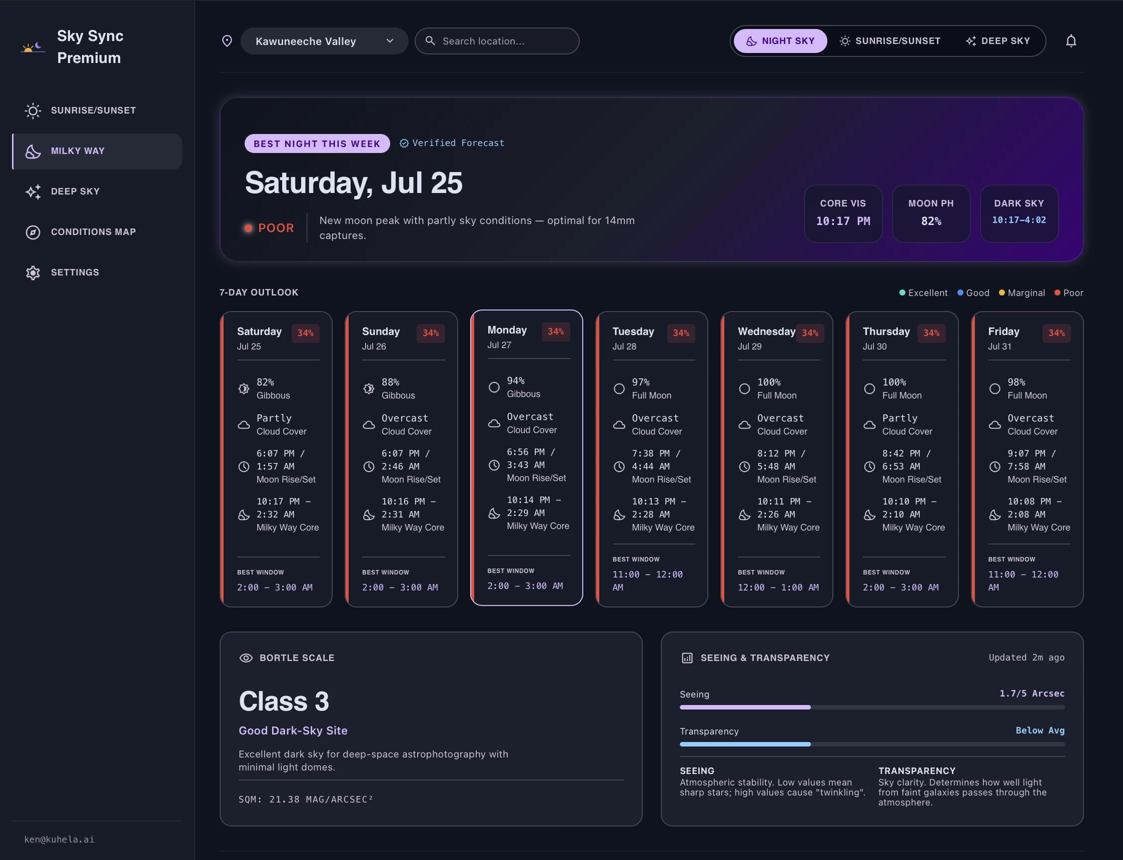
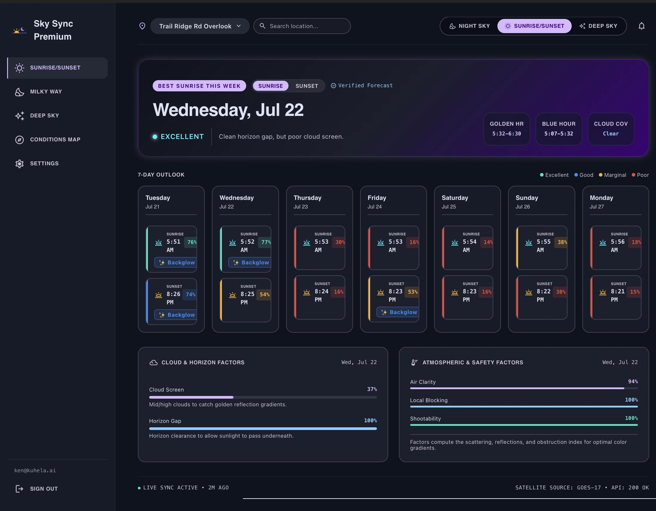
Every night gets a Sync Score, moon phase, twilight window, and cloud cover reading, along with a burn score for every sunrise and sunset. One card per event, ranked so the best one finds you.

Sky Sync 7-Night Outlook
Sunrise / sunset: new

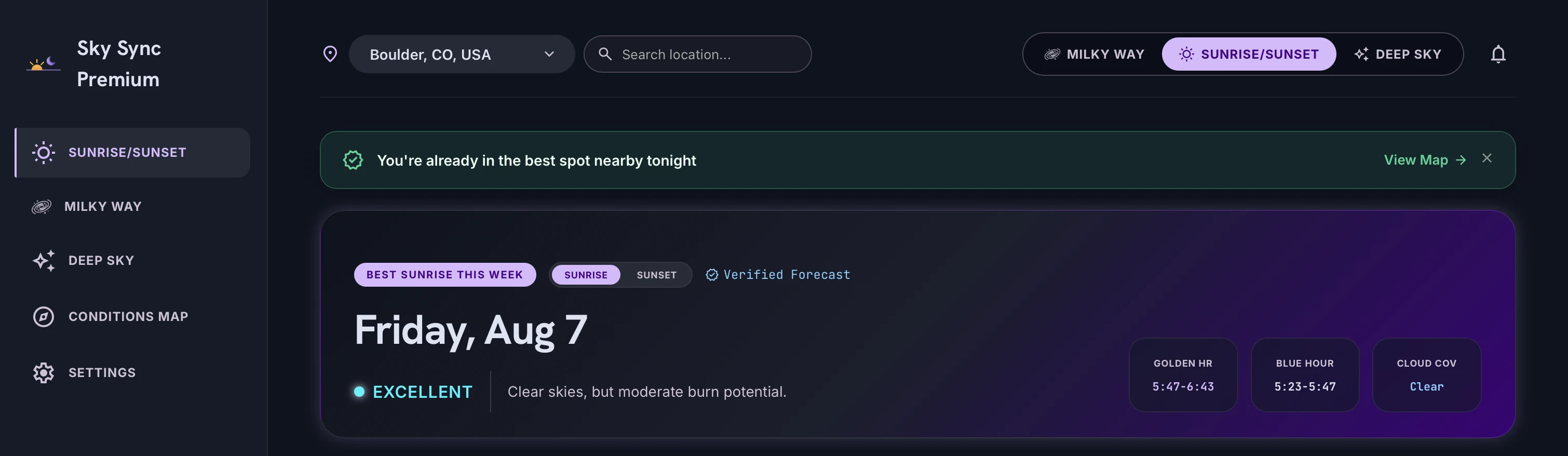
Know if it's going to burn

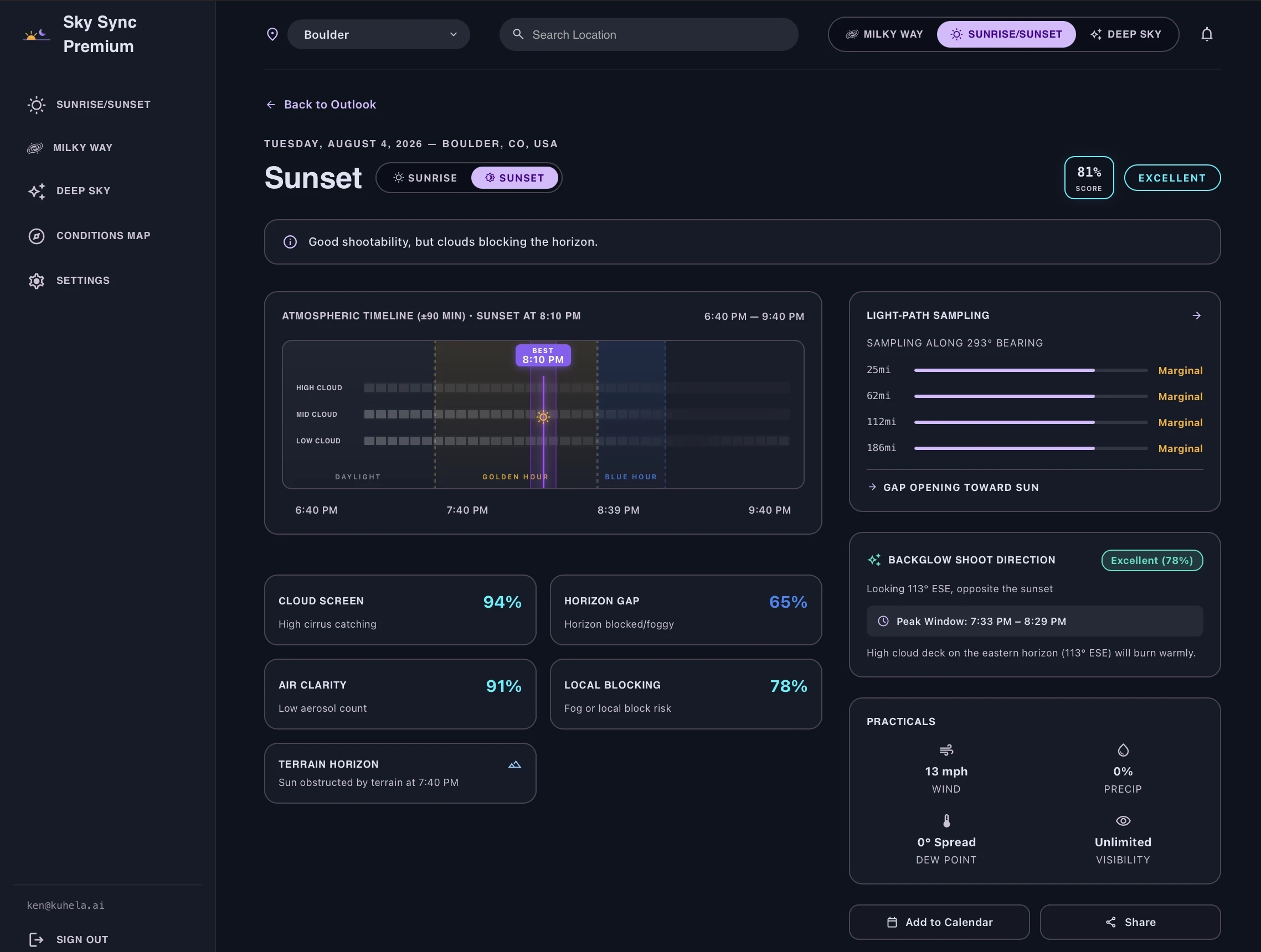
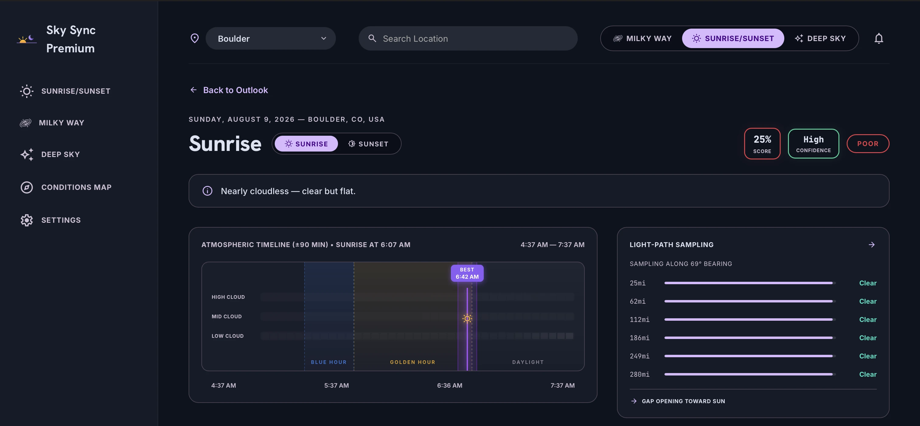
Light-path sampling checks cloud cover up to 180km along the sun's path, because a real burn needs light traveling in from beyond the horizon. Cloud screen, horizon gap, air clarity: one score for every sunrise and sunset this week.

No more separate sunset-predictor app. It's just another mode.

Sky Sync Sunrise and Sunset Detail
Backglow: Exclusive

Sometimes, the sky behind you matters more.

Every sunset app scores the sky in front of you. Backglow is the first to score what's happening at your back. The clouds and mountains 180° behind the sun, where alpenglow and cloud burns often outshine the main event.

Sky Sync Backglow Feature
Post-Storm Clearing

Catch the window when a storm breaks

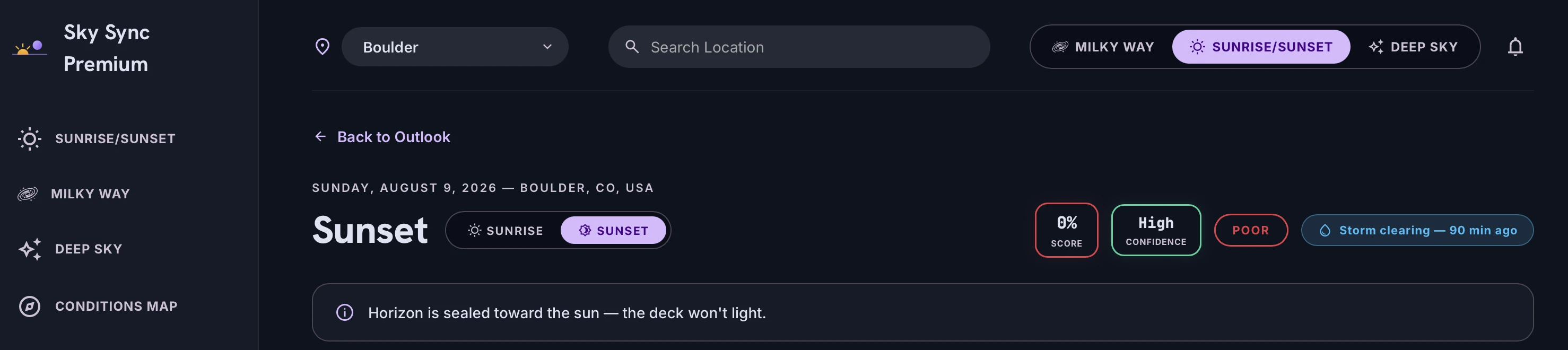
Post-storm clearings create some of the most dramatic light of the season, but the window closes fast. Sky Sync detects recent precipitation and rapid cloud clearing nearby, badging active clearing windows so you never miss the break.

Sky Sync Post-Storm Clearing Detection
Detail view

Every factor, explained

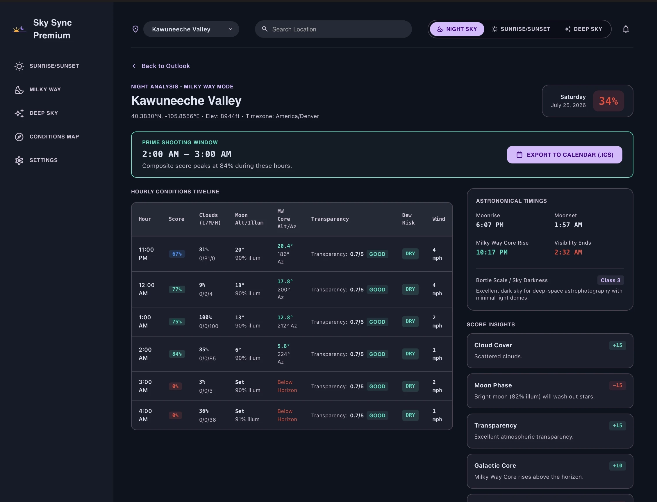
Sync Insights break down exactly what's pulling your score up or down, hour by hour: transparency and seeing for a night out, cloud screen and horizon gap for a sunrise or sunset.

Sky Sync Factor Details
Map

Plan the shot, not just a trip

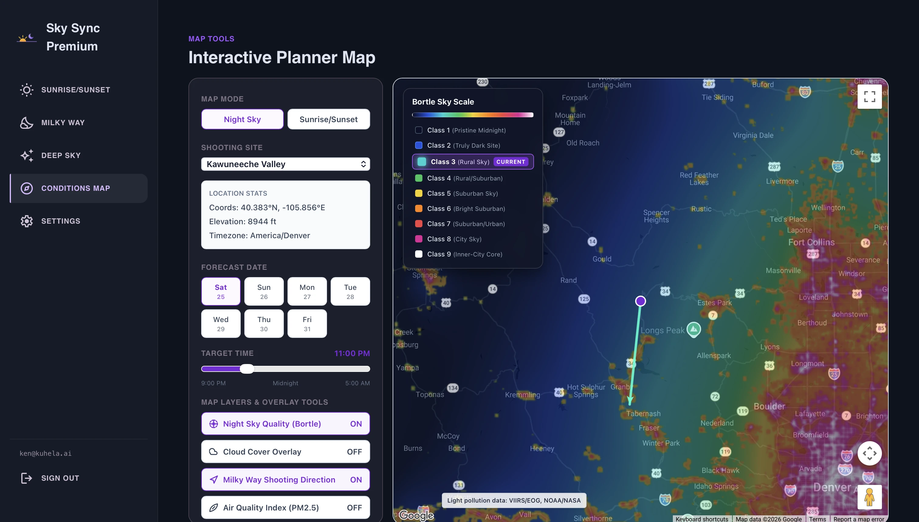
See light pollution, cloud cover, air pollution, and the exact bearing of sunrise/sunset or the Milky Way core, all layered on a map so you can compose your shot around actual conditions.

Sky Sync Bortle Conditions Map
Worth the Drive

Know which spot is actually worth the trip

Unlike broad regional heatmaps, Sky Sync automatically compares your own saved spots against each other and surfaces a personal recommendation, so you know exactly which of your locations has the best window this week.

Sky Sync Worth the Drive Location Comparison
Alerts

We'll tell you when it's worth it

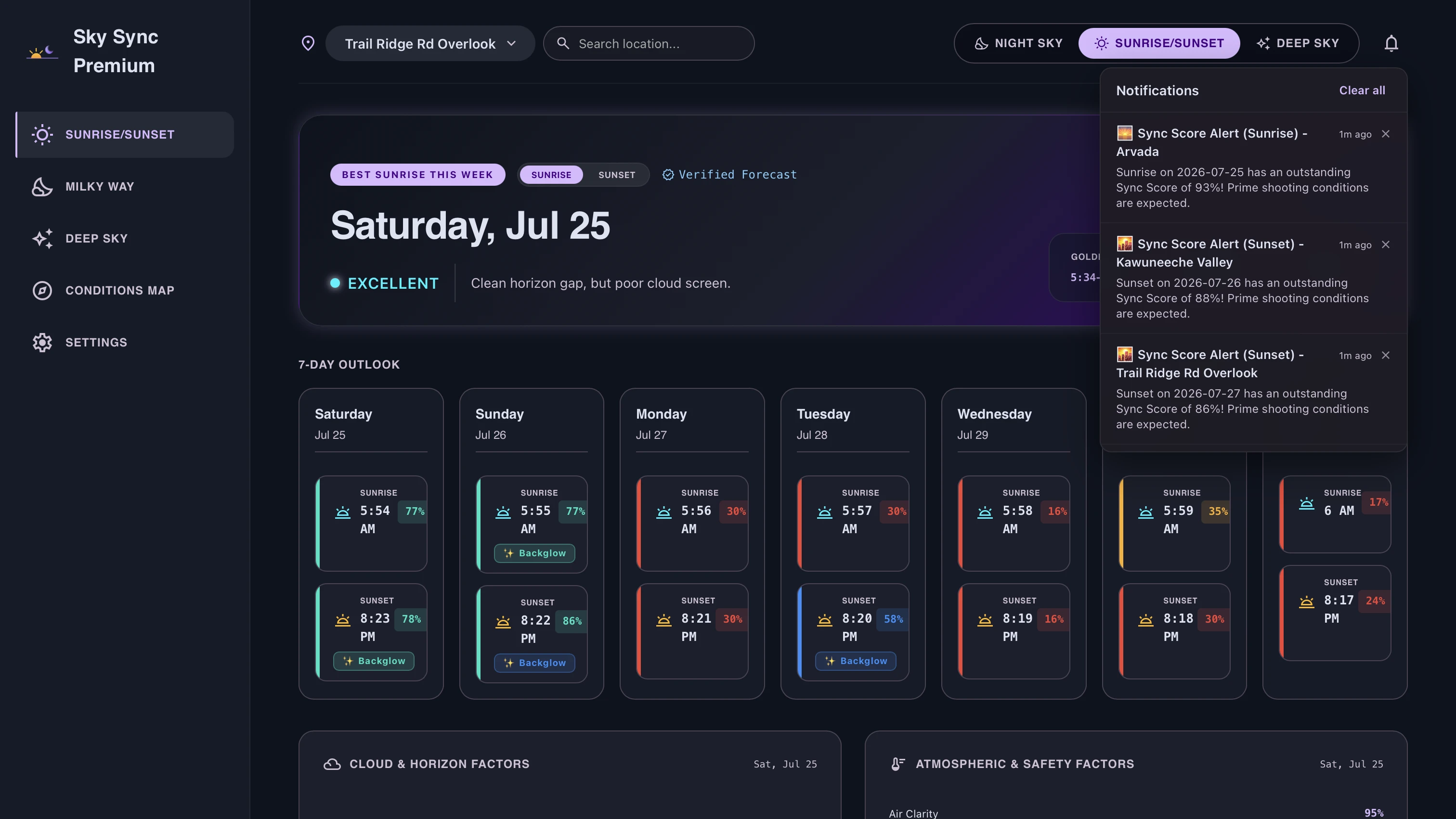
Get pinged the moment a saved location crosses Excellent, for any mode. Stop checking and start shooting.

Sky Sync Weather Alerts
Ensemble Confidence Premium

Know how reliable the forecast really is

A single score number can hide forecast uncertainty. Sky Sync evaluates agreement across multiple ensemble forecast models, surfacing High, Medium, or Low Confidence badges so you know when a forecast is rock-solid versus when models diverge.

Sky Sync Ensemble Confidence Bands

Built for what you're actually shooting

SUNRISE / SUNSET MODE

Catching the burn

Cloud-screen quality overhead and behind
Horizon gap along the sun's path
Air clarity & haze
MILKY WAY MODE

Chasing the core

Galactic core visibility window
Physical moon-brightness model (scattered moonlight vs sky darkness)
Core azimuth & altitude
DEEP SKY MODE

Stacking the faint stuff

Atmospheric transparency
Seeing (stability)
Moon-to-target angular separation

Free tier, honestly free

Full 7-day outlook and event detail are free for Sunrise/Sunset. Premium unlocks 7-night Milky Way detail, Deep Sky mode, more saved locations, and unlimited alerts.

Free
$0 / month
3 night Milky Way outlook
7 day Sunrise/Sunset outlook
Rating & "why" for every night
Full 7-day Sunrise/Sunset event detail
1 saved location
1 alert (Good or better)
Static Bortle rating
No annoying ads
Start free
Free Users Get a 7-day free trial of Premium · No card required
MOST POPULAR
Premium
$3.99 / month
7 night Milky Way outlook
Full detail across all modes (incl. Deep Sky)
Deep Sky mode unlocked
Up to 10 saved locations
Unlimited alerts, custom thresholds
Fully interactive night sky map
Add to calendar
Go Premium
.

"I already have PhotoPills, why do I need Sky Sync?"

PhotoPills tells you where the light will be. Sky Sync tells you whether it's worth planning around at all. It's the five-second check before you open PhotoPills: one glance at the next seven nights, scored for your shoot type, so you only reach for the planning tools when it is actually worth the drive.

Astronomical Atmospheric Environmental → One score

Right now, deciding whether to drive out for a shot means checking a weather app, a moon-phase app, a light-pollution map, and a cloud forecast — then doing the mental math yourself. Sky Sync does that math for you, every night, for the week ahead.

Three ways to shoot

Pick your target. Sky Sync scores it differently.

Milky Way

Know exactly when the galactic core is up, the sky is dark enough, and the moon is out of the way.

Deep Sky

Built for astrophotographers who care about steady, still air — not just a clear sky.

Sunrise / Sunset

TA score based on burn potential, not just the skies above you. The unique Backglow score tells you if you'll have a great alpenglow shot in the morning, or a killer beach sunset on the East Coast.

See it before you drive

Five seconds to a decision

7-Night Outlook

Your whole week at a glance, color-coded, with the best night flagged so you're not scanning seven rows of numbers.

For the technical read
Each night/event resolves to a single composite score mapped to four tiers — Excellent / Good / Marginal / Poor — using shared thresholds across all three shoot modes, so the color language means the same thing everywhere in the app.

Best-hour callout

We don't just rate the night — we narrow it down to the single best window to be in position, camera ready.

For the technical read
Best-moment evaluation runs at finer time resolution within the scored window, so the callout reflects short-lived peaks in cloud clearing or light quality that a single nightly average would wash out.

Regional heatmap

See which direction has better conditions tonight before you've even picked a spot to drive to.

For the technical read
Precomputed on a gridded tile layer sourced from the same NOAA models as the point forecast, cached after first request so repeat views are instant rather than re-scored on every load.

Worth the Drive comparison

Proactively compares your saved spots and highlights which location offers the strongest conditions for the upcoming week.

For the technical read
Runs comparative scoring across all user-saved location coordinates using composite event ratings, surfacing top-ranked locations directly on the home dashboard to eliminate manual multi-spot checking.

One glance, every mode

Milky Way, Deep Sky, and Sunrise/Sunset all live in one app with one visual language — switch modes without switching apps.

For the technical read
All three modes share the same location model, forecast pipeline, and rating vocabulary, with mode-specific factor weighting underneath — so the map, the outlook, and the color coding behave identically no matter what you're shooting.
Built for real terrain

Not just a weather app with a filter on it

Post-storm clearing detection

We detect when a storm system has just broken and cloud cover is clearing rapidly, flagging high-potential post-storm light opportunities.

For the technical read
Monitors precipitation recency and cloud clearing trends across a multi-hour lookback window, surfacing an active clearing badge for near-term events and applying a score bonus to the light-path horizon gap evaluation.

Directional light-path sampling

For sunrise and sunset, we check whether light can actually travel to you along the horizon — not just whether the sky directly above you is clear. A clear sky over your head means nothing if the horizon is sealed.

For the technical read
A fan of rays is projected along the sun's azimuth at the event, sampling low/mid cloud cover at multiple distances out to the horizon, weighted toward the far samples where the light actually enters under the cloud deck. A clearing gradient toward the sun adds a bonus; a sealed near-horizon hard-caps the overall score, because a sealed horizon makes a burn physically unlikely no matter how good the sky overhead looks. Directional optical depth is also checked along the sun's corridor.

Terrain-aware horizon

Built on 30-meter elevation data, so a sunset that's actually blocked by a 14er doesn't get a great score just because the forecast sky is clear.

For the technical read
National terrain-horizon profiles (Copernicus DEM GLO-30 / USGS 3DEP) gate the light-path score at each bearing: if the sun's apparent altitude at event time sits below the local terrain horizon, that path is scored as blocked. Missing terrain data fails open rather than penalizing the score — the system never guesses at a horizon it can't see.

Physically-grounded cloud & moon modeling

We don't just look at generic cloud percentages or raw moon phase — we evaluate physical cloud altitude and thickness, as well as scattered moonlight brightness against local sky darkness.

For the technical read
Cloud-screen factor scores base and top altitude directly (distinguishing cirrus from stratus decks). For night sky modes, a physical scattered-moonlight brightness model accounts for moon position, altitude, and local Bortle sky darkness rather than treating moon phase as a generic percentage.

Speciated aerosol handling & air clarity

Sky Sync distinguishes between different atmospheric haze regimes—smoke, dust, sulfate, and marine haze—scoring each based on how it actually affects light transmission and color.

For the technical read
Classifies atmospheric optical depth into distinct environmental aerosol regimes (dust, smoke, sulfate, marine, clear/mixed). Dust and smoke follow independent optical transmission curves—accounting for dust maintaining directional light transmission longer before reaching total opacity—with directional corridor sampling checking air clarity along the sun's trajectory.

Backglow: the sky behind you

Every factor above scores the sky in front of you. Backglow checks the opposite horizon too — the direction alpenglow and cloud burns come from when you turn around at sunrise or sunset. It only surfaces when there's genuinely something back there worth the turn.

For the technical read
Backglow reuses the horizon-gap and shootability factors from the primary event score rather than recomputing them, since sun-side clearance and wind/precip don't change depending on which way the camera's pointed. It adds two new checks: cloud cover sampled at 10, 30, and 60 km along the anti-solar bearing, and a terrain-relief lookup against the same national terrain-horizon dataset used for the sun-side gate like a mountain range can catch direct alpenglow with no cloud at all. Either source can carry the score on its own; a flat coastal cloud burn and a clear-sky mountain glow are both scored on their own merits, with no bias toward one or the other. If the sun-side horizon is sealed, Backglow caps low regardless, light has to clear the true horizon before it can reach anywhere, including behind you.

Light pollution & Bortle map

See true sky darkness at any location, not just a generic "rural" or "urban" label.

For the technical read
Sourced from annual VIIRS radiance composite data, rendered as a dedicated map layer with Bortle-scale classification independent from the tile's visual color rendering, covering the continental US, Alaska, and Hawaii.

Foreground orientation helper

For a saved location, see the compass bearing of where the Milky Way core — or the sun — will actually sit, so you can plan your composition before you leave home.

For the technical read
Derived from precise astronomical event geometry (azimuth and altitude at the event time), surfaced as plain compass bearings rather than an elevation-aware directional widget — accurate great-circle geometry, without implying a terrain-visibility precision the bearing display itself doesn't claim.
Never a black box

You always know why

Ensemble confidence bands

Surfaces forecast certainty alongside the Sync Score, so you know whether weather models tightly agree or diverge on an outcome.

For the technical read
Evaluates score spread across a stratified sample of NOAA GEFS ensemble forecast members to compute High, Medium, or Low confidence tiers, automatically suppressing the badge when ensemble member density is insufficient for a reliable read.

Plain-language "why"

Every rating comes with a one-line reason you can actually understand — not just a number you have to trust blindly.

For the technical read
Explanations are generated deterministically from the underlying factor breakdown using a fixed rule set — never an AI-generated guess — so the same conditions always produce the same explanation, and the reasoning is fully auditable.

Data-quality transparency

If a signal is missing — a horizon sample, a terrain profile — we tell you. The score never pretends to be more certain than it actually is.

For the technical read
Every scored night or event carries a data-quality tag — full, partial, or degraded — with factor weights automatically redistributed when a signal is unavailable, so a partial data gap shows up as reduced confidence rather than a silently wrong score.

Composite score, fully explained

Tap into any night to see exactly which factors pulled the rating up or down — transparency, not just a black-box number.

For the technical read
The breakdown panel shows each weighted factor (sky, moon, atmosphere, terrain, air clarity, wind) individually, alongside the composite, so the score is always traceable back to real physical inputs.

7 nights out, not 3

Plan a trip days in advance — park permits, drive time, elevation gain — instead of finding out the night before that it wasn't worth the drive.

For the technical read
The forward window blends short-range high-resolution models for near-term precision with longer-range global models further out, so the full 7-day view stays populated and self-consistent rather than dropping to a coarser fallback after day two or three.
Sky Sync Sky Sync

Know before you drive.

Product
Company
Legal
© 2026 Kuhela. Sky Sync is a sibling product of Shutter Sync.